Drone Tech for Community Participation in Conservation, Agriculture, and Advocacy
Community groups and interested individuals learnt how to build and fly their own drones in a recent weekend workshop at the Valldaura Green Labs site in the forested foothills just above Barcelona. Together with Lot Amoros and Alexandre Oliver of Flone-Drone we learnt to build a drone, soldering all the parts together, and conquered the coordination of piloting our tech.
Putting drone technology in the hands of local residents and community groups is essential. Around the world, communities, independent businesses and startups are finding new ways to use drones to aid conservation and environmental management projects, urban planning, precision agriculture, and landscape modelling. Valldaura GreenLab is committed to helping community members add drone tech to the list of skills that we can use collectively to protect and preserve our environments and communities.


How communities are using drones
In North-Western Australia, drones are being used by ecology researchers from Monash University to map nesting seabirds on remote islands, without causing disturbance to the local species. In Nepal, the community group ConservationDrones are partnering with the WWF to use drones to conduct anti-poaching surveillance. International poaching affects endangered species, including rhinos and elephants in Nepal, but is also used to support an illegal trade in fishing, illegal cattle grazing and logging. Already the drones are having an impact, leading to more poaching arrests and saving rhinos and precious forest land.
In Colorado in the United States, the startupDroneMapper is looking at the use of drones to help farmers to “increase crop yield, help determine problem areas, and save time.” Using drones for precision agriculture can help farmers to better work with the natural ecosystem, such as understanding water flows across a property, and to better manage resources.
In Dallas, also in the U.S., a local citizen testing out his hobby drone contacted local community advocacy agencies after taking pictures showing a meat packing plant was illegally emptying pig blood into a local waterway via an underground pipe. “It is my hope that with these new skills and tools, communities will begin to see drones as a viable instrument of investigation,” said Jonathan Minchin, Coordinator of the Green Fab Lab Valldaura, and workshop organiser.
It is a sentiment that is shared by Associate Professor Lian Pin Koh, Founding Director of ConservationDrones: “Commercially available drones can easily cost more than tens of thousands of dollars, and are too expensive for conservation and community projects,” Lian explained. “Fortunately, there are an increasing numbers of open-source and grassroots level initiatives for developing drone systems that can perform just as well if not better than commercial systems. These do-it-yourself drones are typically very affordable. But more importantly, by learning how to build these drones themselves, the users would know how to maintain and repair them when necessary.”
Learning to pilot a drone
One of the most fun activities in the workshop was the hands-on learning of how to pilot a drone. Justin Edwards is a drone photographer based in Maui who regularly volunteers on creative and non-profit drone projects, and has built a successful business offering aerial photography services using a drone. He wrote to us to share some of his tips on drone piloting.
“I think one of the most important skills you have to learn when you are starting out is orientation,” Justin (who has written several books on starting an aerial photography business) shared by email. “Remember that with remote control models, right is always right and left is always left no matter if the aircraft is pointed away from you or towards you.”


Justin recommends: “Practice with the tail end facing you, then nose, and finally the sides. Once you can keep from getting disoriented, you can start working on forward flight. I try and keep the drone tail towards me because it is the easiest way to fly but you have to be prepared for the unexpected and know how to fly in any direction to avoid costly crashes.”
A kung-fu approach to drone flying
Our workshop was taught by Lot Amorós, makers of the Flone-Drone. Flone-Drone is an entry level drone that works with Android. The flone-drones were used for some aerial land surveying trials by participants. Valldaura was lucky to have Lot Amorós and the team from Public Lab on hand to help build the flones and conduct aerial mapping experiments.
“Public Laboratory for Open Technology and Science (Public Lab) is a development community to apply open source tools for environmental exploration and investigation,” the Lot Lot Amorós website says. “It is about democratizing accessible, DIY techniques in a network of community members who are reimagining how we relate with each other. In this intensive workshop, participants fly the flone-drones utilising an app on an Android smartphone. We will practice with these new technologies to learn how to fly the drone, like in a mind and body kung-fu tradition.”
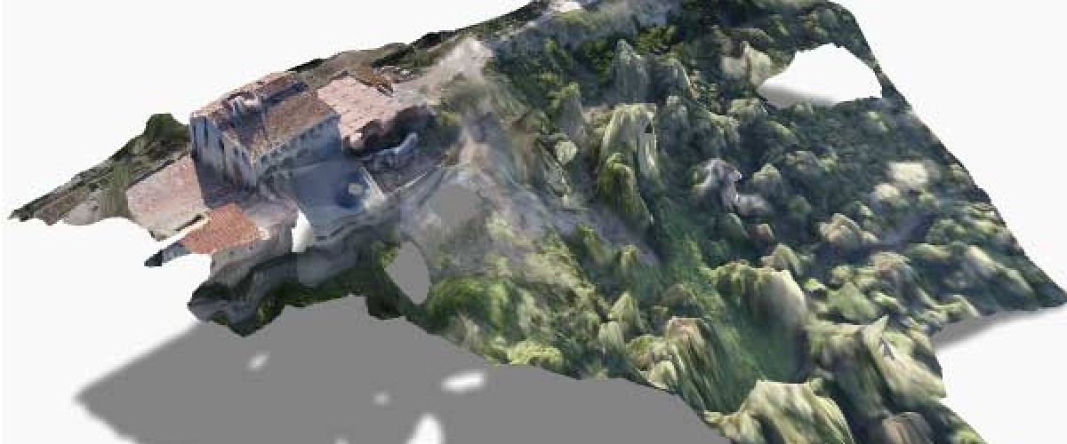
Data mapping
Already, 3D maps have been created to detail the Valldaura green site in greater detail and with a never-before-seen perspective. We are excited to make use of this technology in thinking through the site in the future.


“It is important to think of the drones as a means to an end and to turn the attention to what real information needs we have,” Jonathan said. “In particular, drones and the sensors they carry deliver the capacity to analyse and monitor large areas of land, track biodiversity and reveal acute differences in ecotones and living systems. So the question turns into: How can local communities take up drones in a useful way? How can instrumentation go beyond mere mapping to deliver targeted and useful information that responds well to local and particular issues?”
A future workshop looking at advanced mapping skills with drones is being planned in the next few months.
Contact us for more information.
Written by : Mark Boyd