Forestry Zero Winter/Spring
In the modern age, land use has become a global issue of
importance, where large swathes of the earth are
occupied and managed for Human productivity. The
Anthropocene describes an epoch of human made biomes,
that have social, political and environmental impacts. The
Forestry Zero seasonal program is a set of 5 day
immersive introductions to the practical techniques and
novel management strategies that take the Forest into
the future at the Valldaura Labs campus. Bringing
together active experience with innovative digital
technologies.
Workshop participants will gain knowledge of traditional
and historic forestry and silviculture practices, they will
understand the planned and novel frameworks for the
Collserola park both current and into the future. Learning
how to identify species, digitally scan tree morphology,
use digital fabrication tools and learn how to record and
understand ecosystems. Both felling and planting, We will
use DIY embedded electronic devices to geolocate and
map the forest and use territorial computation to
augment our experiential knowledge. Adding data to track
material and energy through the forest and Laboratories.
The Forest of Valldaura Labs covers over 130 Hectares of
the Sera de Collserola park. The recorded history of its
management connects back to the 11th century when the
territory was used as a hunting grounds for the nobility.
Over the centuries the land and forest have gone through
massive change. From clear cutting to agriculture,
abandonment and regrowth. The forest is now managed
to improve its health, its bio-diversity and productivity. It
is also a biotic and material resource and the origin and
the driver of the intension to create a circular local
economy and living system at Valldaura Self Sufficient
labs.
The Winter and Spring Forestry workshops can be taken
alone or in series. They are taught in conjunction with
‘Social Forest’ and the Green Fab Lab. Inspired by the plan
to action of the Administration of the Collserolla park;
towards a smart, productive and sustainable forest
habitat.
Price :
325 euros
Accommodation :
Available and Optional Kitchens and restaurants onsite.
Contact :
[email protected]
Registration form:
http://apply.fablabbcn.org/view.php?id=11367
Properties of the plant. Mosses are small flowerless plants that chiefly grow in areas of dampness and shade, such as wooded areas and at the edges of stream. The individual plants are usually composed of simple, one-cell thick leaves, covering a thin stem that supports them but does not conduct water and nutrients. Mosses are very robust: they can grow anywhere in cool damp cloudy climates, and some species are adapted to sunny, seasonally dry areas like alpine rocks or stabilized sand dunes. Mosses require high levels of moisture to survive because of the lack of a vascular system, and the need for liquid water to complete fertilization. Many mosses can survive desiccation, sometimes for months, returning to life within a few hours of re-hydration.
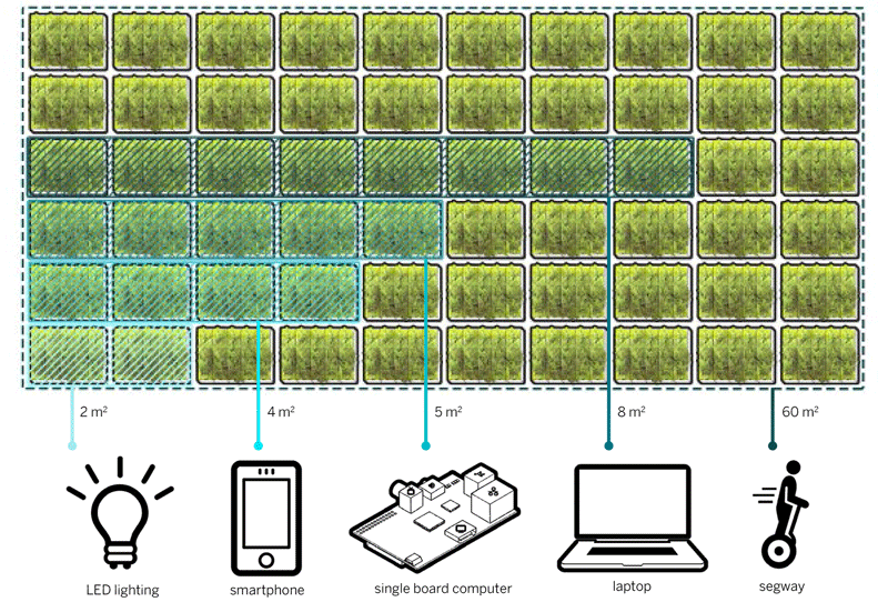
Urban application: As mosses are also found in cracks between paving stones in damp city streets, and on roofs there is a possibility to spread the system into the urban environment. Some species adapted to disturbed, sunny areas are well adapted to urban conditions and are commonly found in cities. Mosses are sometimes used in green roofs. Advantages of mosses over higher plants in green roofs include reduced weight loads, increased water absorption, no fertilizer requirements, and high drought tolerance. Since mosses do not have true roots, they require less planting medium than higher plants with extensive root systems. With proper species selection for the local climate, mosses in green roofs require no irrigation once established and are low maintenance. Compared with silicon-based photovoltaic cells, a solar cell that uses biological material to capture light energy would be cheaper to produce, self-repairing, self-replicating, biodegradable and much more sustainable. The manufacturing process is harmless to the environment.Furthermore BPV panels can exist in the places where solar panels are not efficient – northern countries with the lack of direct sunlight.
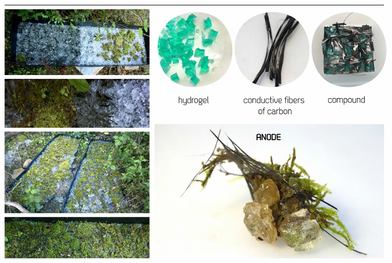
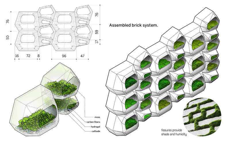
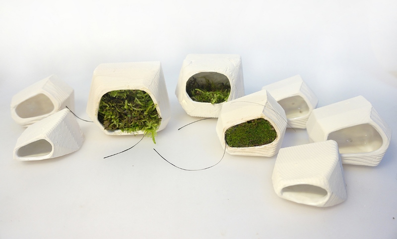
Biophotovoltaic cell represents an organization of units combined in series or parallel circuits. Unit is a full operating bio-electrical system. It consists of the anodic biological material (moss), the anode, the cathode, the “salt bridge” that permit to the positive charge (generally protons) to travel from the anodic biological material to the cathode. The anode represents the mixture of hydrogel and carbon fibers that help to attract the electrons. Hydrogel is a polymer that can absorb water up to 400 times to its weight, it keeps complementary humidity for the moss and it is pH neutral. The materials are not damaging any metabolism. Thus first tests to check how fibers coexist with moss and polyacrylate were made. One unit 100×100 mm: for the anode were mixed carbon fibers and hydrogel in cubes (sliced for thinner small sheets) + a layer of carbon fabric, the mixture was covered with moss. The cell showed 0,35 volts. Meanwhile “moss plantation” was set up in Valdaura wherefrom anode would be taken for embedding it to the structure. For this fibers with polyacrylate were mixed and moss was placed atop and pressed down + moss was divided in small pieces and distributed over the same mixture. After 1 months moss grew through the mixture.
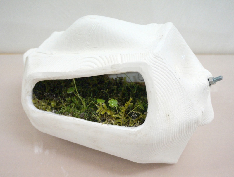
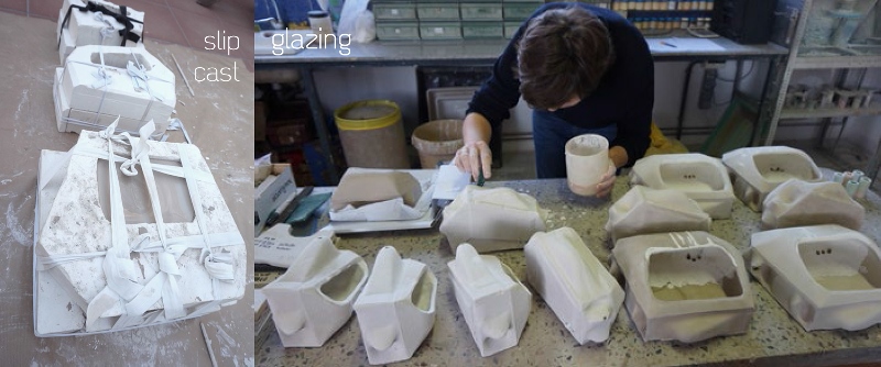
Design of a system. Bricks represent sort of a container that can create special microclimate that helps to keep moss alive. The bottom part inside that brick is glazed to be waterproof, the rest is a porous clay without a coating. This clay absorbs water, so the system could be passive receiving water from rain, where hydrogel retains liquid for a long period.
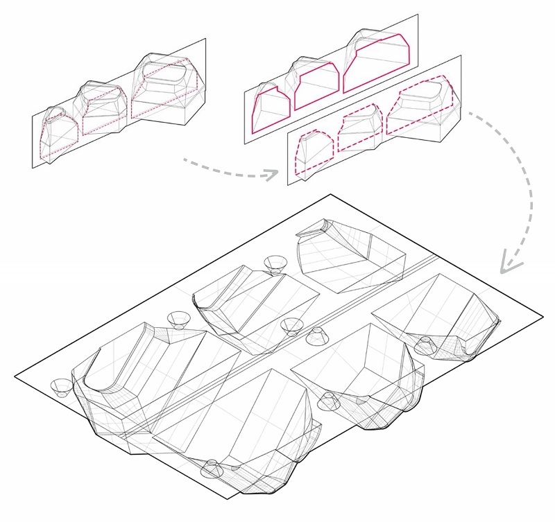
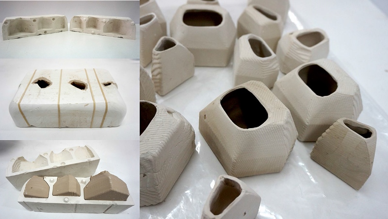
The first elements were made to see if the method of slip clay casting works. Slipcasting is a technique for the mass-production of pottery and ceramics. A liquid clay body slip is poured into plaster moulds and allowed to form a layer, the cast, on the inside cavity of the mould. For a hollow cast mould, once the plaster has absorbed most of the liquid from the outside layer of clay the remaining slip is poured off for later use. Generally there are few steps in making a plaster mold: a) forming a shape made of clay; b) formwork around the matter + several divisions for pieces of the mold; c)pouring liquid plaster. In this project those items have been overstepped, the plaster mold was done with the milling CNC machine. So the shape was created digitally that means accuracy and precision.
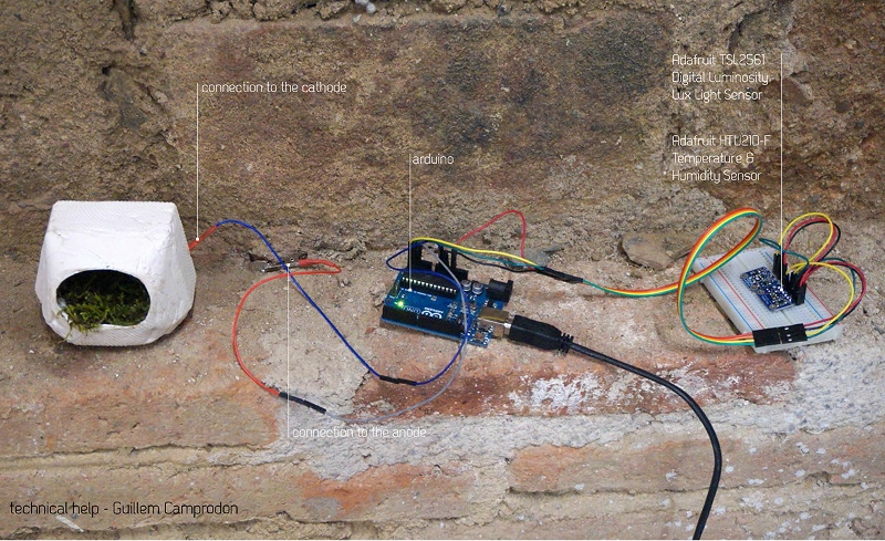
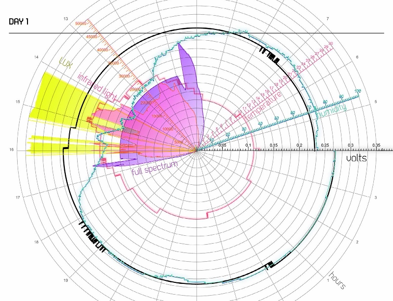
Receiving data. There was made a device that can read Lux, Humidity, Temperature and Volts every 5 seconds with sensors and save it directly to .csv file. Here is a graph with 4 days, where you can see the relation of voltage and humidity.
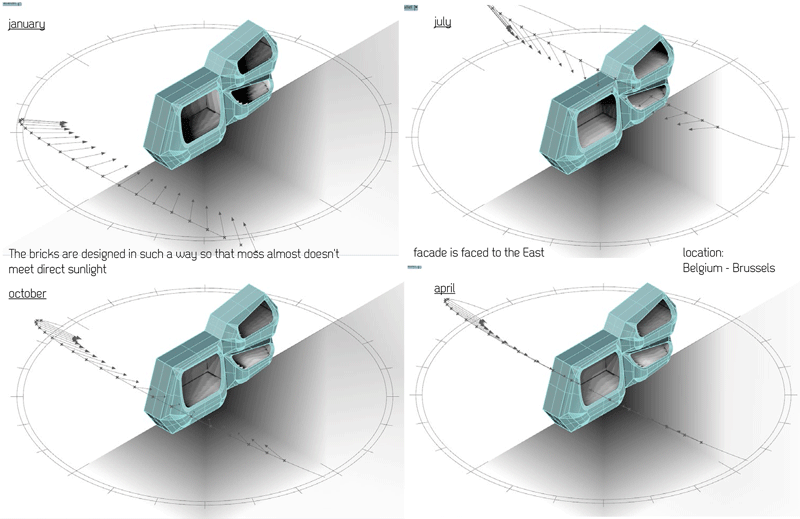
The initial idea is to go for the facade, so the scale of the first prototype was quiet small considering it as a ventilated facade brick. As far as the customization technic and the electrical components are functioning the shape transfers to a new design. It is predicted by the system of assembling, by the forces that are distributed through the whole volume, and by the specific conditions linked with the fabrication process (the size of bits for milling, the quantity of pieces for the mold, the way clay is casted). Elements are gathered by the relief on their side faces without adding any cement mixture. Electrical connections are passing through those system joints. Moss is not exposed to the direct sunlight, blocks provide the required shading.
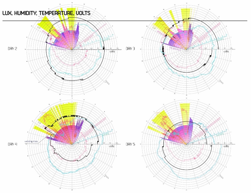
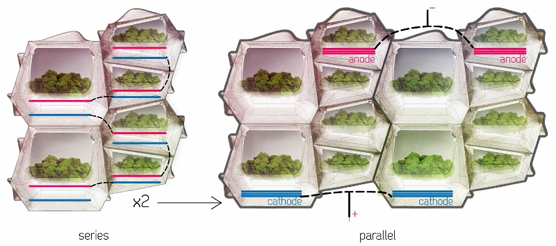
One Unit is giving 0,4 – 0,5 Volts. Six bricks are connected in the series circuit to increase the voltage- 3 different modules, two of each ones. Two and more groups that were connected in series are combined in the parallel circuit to increase the current.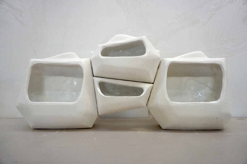
the project is done by
Elena Mitrofanova
scientific development
Paolo Bombelli
advisors
Luis Fraguada
Silvia Brandi
Alexandre Dubor
collaboration
Ceramica Cumella
special thanks
Ivan Mitrofanov <3 <3 <3
Valldaura GreenLab team
Guillem Camprodon
Fabienne Felder
Iker Luna
]]>The ecological emergency and the global energy crisis are driving us to rethink architectural design in terms of optimization of local resources, reduction of water and energy requirements, and integration of technologies producing energy from renewable sources. Sustainability issues have already been transforming building’s function from places to live to multifunctional systems integrating energy production and, always more frequently, food production, including roof top or hydroponic indoor agriculture. The ProdActive Landscapes project proposes to use the same complex approach in landscape design, as intermediate and essential step between complex Actives buildings and the complexity of the city. In order to evolve the public space design from the contemplative and leisure, passives, functions into an urban space of food and energy production.
ProdActive Landscapes is a parametric model of territorial productive potential assessment, that far from suggest a deterministic way to design, wants to be an instrument of conscious design in order to create a network of re-signified green urban areas working as one diffuse system of energy production as alternative to the actual model of renewable energy extensive systems.
ProdActive Landscapes is proposed for the service of local community and landscapes designer, who wants to integrate renewable energy production in that existing high density neighborhood where power demand is non reachable just by ordinary rooftop PV systems technologies. The model purpose an integrated system of traditional agriculture, waste water treatment with herbal purification, water collection, biomass production, and bio-PV energy production, looking for the way to optimize the land surface in order to respect sustainability issues .

Pick the ground
Land Analysis Process
The Analysis process starts from Geographic Information System providing by internet access most of data required as land morphology, weather data, soil quality, productive potential by using several on lines database.
ProdActive Landscapes is a dynamic model. It means that allows several ways of use consistent with different ways to design. For example, it is possible to evaluate the maximum productivity starting from land analysis, obtaining the maximum human charge supported in a self-sufficient environment, or to start from a local community of residents in order to study its specific requirements, in term of land’s surface, to collect water, purify water with herbal purification, produce vegetable, milk eggs etcetera.
A solar analysis provides a first discrimination of land. In order to evaluate productive potential, the model gives as output a “potential food production map” and the number of persons “feed-able” for each crops category ( cereals, olives, vegetables) as the same way as for milk/eggs or meat productions; defining the maximum community supported by that territory depending on nutritional model too, vegan, vegetarian, or general.

Seed the sky
The landscape’s productivity evaluation is just the first stage of ProdActive Landscapes project. The second stage basically consist in design an module for agricultural production parametrized for rooftop agricultural production as well as urban gardening automatically adaptable at specific environmental condition , specially solar radiation, to optimize energy production by solar pv or bioPV . This gardening module easily download-able an Fab-able in every Fab Lab will integrated sensor to collect environmental and production data feedback of all the network of new Energy-gardeners around the world.
]]>


P2P Food Lab is about YOU and FOOD.
The P2P Food Lab project aims at developing new socio-economic models for food production chains. We seek solutions that promote the local production, distribution, and composting of food. Our hypothesis is that with the use of today’s information technology and the insights gained from the various “”open”” movements (Open Source, Open Hardware, …) it must be possible to design food production chains that can be more ecological, less hierarchical, and as productive as today’s food industry. The project is also a huge Citizen Cyberscience project: it relies on participants to set up their own experiments, gather data and collectively seek the most effective strategies to grow food.


1. From seed to composter: Get involved with every aspect of the life cycle of your food. For example, P2P Food Lab helps you get started growing your own vegetables. For that reason we developed a Starter Kit to make growing vegetables easy and fun. We also help you exchange food with neighbours or help you set up composting.
2. Bringing the peer-to-peer spirit to food: P2P Food Lab is there to help CITIZENS to organise food production COLLABORATIVELY. Peer-to-peer means that we blur the distinction between food producers and food consumers. Be a food prosumer! It also means that you plan food at a community level, together with neighbours, on a voluntary basis.
3. Technology & tools: P2P Food Lab proposes new tools to help you in the local food production chain. We designed a first version of a small greenhouse together with advanced equipment to measure plant growth. We also provide tools to share your experiences or to ask for help online.
4. Commons: Over time, these exchanges will create a very useful source of know-how about gardening, by and for gardeners. And because we believe in Free Software and Open Hardware, we will make all of our tools freely accessible so that you can improve upon them. Build your greenhouse, your food I/O box, your community garden or your composter using our instructables. Happy Hacking!
Contact : peter (at) hanappe.com or mainguetpierre (at) gmail.com
]]>

Stage 1: The Hives
Over the past two years a distributed team of developers have produced two open source beehive designs; the Colorado Top Bar and the Barcelona Warré. Either hive can be freely downloaded, installed to a CNC router machine, and cut from a standard 4×8 sheet of material, such as plywood. The fabricated pieces are flat-packable and slot together without the need for screws or glues. Both hives have been designed around natural beekeeping methods to lower stress factors on the colony, minimise exposure to artificial materials, and allow the bees more control over their living environment.
Our designs use an open source licence (CC-BY-SA) so anyone can download, improve, and change them to fit their particular needs. The only rule is that you share these new designs under the same open licence so anyone can use and improve them. You can download a hive and build one yourself, or buy one from us. All monies received go towards supporting the Open Source Beehives project.


Stage 2: The Sensors & Data
The Open Source Beehives project is developing a sensor kit that will allow users to monitor bee colony information and upload the data to the an online repository called the Smart Citizen platform. All generated data will be viewable and downloadable by anyone. Accurately monitoring a super organism such as a bee colony is complicated, so we are releasing versions of our sensor kit on an iterative basis. The first Alpha Kit is being developed with audio, temperature, infrared, and humidity sensors. Later versions will include VOC sensors to monitor for foreign chemicals, scales to monitor honey production, and web cameras to give visual information about the colony.
Our sensors are being developed by a distributed team of collaborators. If you have skills in electronics or programming and are interested in helping develop our sensor kit, please contact [email protected].


The project now has more than 60 hives either built remotely or ordered in over 20 countries. In interdum in erat vitae ornare. In scelerisque velit eget tempus dapibus. Proin efficitur urna dui, interdum elementum lacus tempus vitae. Morbi lobortis sodales ante vitae fermentum. Maecenas nec nisl sit amet ex consectetur tristique. Curabitur ac leo vitae dolor suscipit commodo. Aenean viverra ligula rhoncus lacus interdum viverra. Aliquam erat volutpat. Nullam at pellentesque eros.
Two sensor-enhanced beehive projects were initiated independently in 2013, one at the Fab Lab Barcelona Fab Academy by Jonathan Minchin, John Rees, Ferran Massip, Annemie Maes of OKNO Brussels, Hangar Barcelona and the University of Barcelona. The other by Tristan Copley-Smith and Aaron Makaruk. The two projects finally joined together to form the Open Source Beehives project (OSBH).
Feel free to get involved by joining the discussions on our forum or by contacting us.
]]>Community groups and interested individuals learnt how to build and fly their own drones in a recent weekend workshop at the Valldaura Green Labs site in the forested foothills just above Barcelona. Together with Lot Amoros and Alexandre Oliver of Flone-Drone we learnt to build a drone, soldering all the parts together, and conquered the coordination of piloting our tech.
Putting drone technology in the hands of local residents and community groups is essential. Around the world, communities, independent businesses and startups are finding new ways to use drones to aid conservation and environmental management projects, urban planning, precision agriculture, and landscape modelling. Valldaura GreenLab is committed to helping community members add drone tech to the list of skills that we can use collectively to protect and preserve our environments and communities.


How communities are using drones
In North-Western Australia, drones are being used by ecology researchers from Monash University to map nesting seabirds on remote islands, without causing disturbance to the local species. In Nepal, the community group ConservationDrones are partnering with the WWF to use drones to conduct anti-poaching surveillance. International poaching affects endangered species, including rhinos and elephants in Nepal, but is also used to support an illegal trade in fishing, illegal cattle grazing and logging. Already the drones are having an impact, leading to more poaching arrests and saving rhinos and precious forest land.
In Colorado in the United States, the startupDroneMapper is looking at the use of drones to help farmers to “increase crop yield, help determine problem areas, and save time.” Using drones for precision agriculture can help farmers to better work with the natural ecosystem, such as understanding water flows across a property, and to better manage resources.
In Dallas, also in the U.S., a local citizen testing out his hobby drone contacted local community advocacy agencies after taking pictures showing a meat packing plant was illegally emptying pig blood into a local waterway via an underground pipe. “It is my hope that with these new skills and tools, communities will begin to see drones as a viable instrument of investigation,” said Jonathan Minchin, Coordinator of the Green Fab Lab Valldaura, and workshop organiser.
It is a sentiment that is shared by Associate Professor Lian Pin Koh, Founding Director of ConservationDrones: “Commercially available drones can easily cost more than tens of thousands of dollars, and are too expensive for conservation and community projects,” Lian explained. “Fortunately, there are an increasing numbers of open-source and grassroots level initiatives for developing drone systems that can perform just as well if not better than commercial systems. These do-it-yourself drones are typically very affordable. But more importantly, by learning how to build these drones themselves, the users would know how to maintain and repair them when necessary.”
Learning to pilot a drone
One of the most fun activities in the workshop was the hands-on learning of how to pilot a drone. Justin Edwards is a drone photographer based in Maui who regularly volunteers on creative and non-profit drone projects, and has built a successful business offering aerial photography services using a drone. He wrote to us to share some of his tips on drone piloting.
“I think one of the most important skills you have to learn when you are starting out is orientation,” Justin (who has written several books on starting an aerial photography business) shared by email. “Remember that with remote control models, right is always right and left is always left no matter if the aircraft is pointed away from you or towards you.”


Justin recommends: “Practice with the tail end facing you, then nose, and finally the sides. Once you can keep from getting disoriented, you can start working on forward flight. I try and keep the drone tail towards me because it is the easiest way to fly but you have to be prepared for the unexpected and know how to fly in any direction to avoid costly crashes.”
A kung-fu approach to drone flying
Our workshop was taught by Lot Amorós, makers of the Flone-Drone. Flone-Drone is an entry level drone that works with Android. The flone-drones were used for some aerial land surveying trials by participants. Valldaura was lucky to have Lot Amorós and the team from Public Lab on hand to help build the flones and conduct aerial mapping experiments.
“Public Laboratory for Open Technology and Science (Public Lab) is a development community to apply open source tools for environmental exploration and investigation,” the Lot Lot Amorós website says. “It is about democratizing accessible, DIY techniques in a network of community members who are reimagining how we relate with each other. In this intensive workshop, participants fly the flone-drones utilising an app on an Android smartphone. We will practice with these new technologies to learn how to fly the drone, like in a mind and body kung-fu tradition.”
Data mapping
Already, 3D maps have been created to detail the Valldaura green site in greater detail and with a never-before-seen perspective. We are excited to make use of this technology in thinking through the site in the future.


“It is important to think of the drones as a means to an end and to turn the attention to what real information needs we have,” Jonathan said. “In particular, drones and the sensors they carry deliver the capacity to analyse and monitor large areas of land, track biodiversity and reveal acute differences in ecotones and living systems. So the question turns into: How can local communities take up drones in a useful way? How can instrumentation go beyond mere mapping to deliver targeted and useful information that responds well to local and particular issues?”
A future workshop looking at advanced mapping skills with drones is being planned in the next few months.
Contact us for more information.
Written by : Mark Boyd
]]>The event was to explore innovative design and prototyping techniques, NURBS Modelling, Optimisation, and Fabrication strategies. Goal of the event was to construct 1:1 scale pavilion through all different digital fabrication processes.

The event was divided into two different phases: the first one was focused on design, which held in Cairo. Students participated to an internal competition for the design of a data responsive pavilion, which followed by a small presentation and jury has selected one design proposal between all projects. In the second phase, the workshop moved to IAAC (Institute for Advanced Architecture of Catalonia) in Barcelona, Spain. Here students had a direct access to all digital machinery of GREEN FABLAB through that they explored all the process about digital fabrication in order to build their own design.
PROGRAM BRIEF
The workshop allowed participants to develop skills on computational design. According to the parametric design strategy, the building form should not be superimposed. An overview of building science and generative techniques were provided to link form and performance. Participants also gained insight on which computer tools are now-days involved into the design process of built environments.
The computational approach enables designers and architects to overcome the imposition of a prefixed form in order to enhance performance-driven design. Lectures on parametric design, simulation and optimisation techniques, analysis and digital fabrication prototyping, were integrated into the workshop.

OPTIMA+ was divided into four main parts:
A- Tooling
Initially, the workshop introduced parametric modelling and design to participants, built the necessary skills for addressing the technical challenges of using analysis to inform design strategies.
B- Generative Strategies
Form behaviour, analysing and form finding design strategies, response to architectural, urban and environmental contexts. Material system behaviours were digitally translated into parametric models.
C- Optimisation
Applying practically through a hands-on experience in using cutting-edge simulation tools that equipped architects with metrics that support the design of project in surrounding spaces.
D- Fabrication and prototyping
The participants learnt how to prepare their designs to be fabricated by using mainly CNC Machine, some wood workshop tools and related technologies.
